I am a data engineer at CBRE and currently working on a business data model to establish links between plots of land in Netherlands (perceel) and the buildings (pand) that sit on top of this plot.
Currently we get the information for a particular address at all levels (Pand , Verblijfsobject, Nummeraanduiding, etc) from the BAG API while the perceel information is got from ArcGIS Rest API (DKKv4 - Perceel). The perceel information has an id called Kadastrale objectidentificatie which uniquely identifies a perceel.
My question is: Is there a way we can relate the buildings (Pand) to the plots (Perceel) on which they stand? In technical terms, I want to relate the Pand IDs to their respective Kadastrale objectidentificatie.
Till now we have thought of doing a geo-matching because both the BAG and Perceel API provide geometry information which can be used. However, this approach seems difficult to implement and will skip the edgecases where a building may occupy multiple plots of land etc.
Any help or pointers in this regard would be very helpful.
As far as I know from all the public datasets, BAG, BGT, BRK-DKK (v5 now) etc, there is no such coupling. But it is not too hard to derive through geo-matching. Either in PostGIS or with one of the many geodata analysis tools like shapely or GeoPandas.
And in theory a building (Pand) could occupy multiple cadastral parcels (Perceel) and possibly vice versa (stacked buildings).
Just is correct: there is no administrative link between Panden and Percelen available. The only connection you can make is the spatial one, and you;ll have to find a way to deal with the edge cases.
Be aware that there will be a lot of false positives, especially with what we call ‘rijtjeshuizen’ in Dutch. To avoid a lot of those, your best bet is to overlay the Verblijfsobjecten on the Percelen, then find the Pand ID’s with the Verblijfsobjecten. That would avoid most of the cases where the edge of a Pand lies on the edge of two parcels for example. But you’ll miss the Panden without Verblijfsobjecten using this method. I can’t say whether that poses a problem for your use case or not, if it does you could also work with overlap: the more a Pand and a Perceel overlap, the greater the chance they belong together. Although even that method is not perfect: I once worked for a gemeente, where the builders had built a house 15 centimeters across the perceelsgrens. To avoid any issues in the future, we split that 15 centimeters off, created a new parcel (15 cm wide, 9 m long) and signed it over to the owners of the building…
Stuff like that unfortunately happens, and that will mess up any spatial comparison you can make. But right now it’s the only way to link Panden en Percelen.
An effort is made by the Dutch Kadaster to link BAG addresses -via BAG PANDEN- to cadastral parcels. The result -with a range of false positives, no results, etc- is incorporated in the PDOK locatie server (Introductie - PDOK). For a given address, it gives you the parcel(s) on which the related pand is situated.
That is true, but it contains a lot of quite surprising results. There have been discussions on this forum about the list of percelen that the Lokatieserver returns with an address, and in this thread I have given a few examples of perceel-pand links given by Lokatieserver that make no sense if you look at them from a spatial perspective. Since no explanation was given/can be found as to how that link is made, and what decisions it was based on, I do not trust that link (especially not given the examples I’ve shown in the previously mentioned thread). That’s why I won’t recommend using Lokatieserver as a source for this information.
I do think that the issue should be adressed somehow,because this subject returns quite frequently, as you can see from these search results. But when it IS addressed, it should be documented how the link is made, and that documentation should be publicly available, in my opinion…
In my younger years (more than 10 years ago!) I worked on -and documented- the first version of the BAG - BRK relationship. My memory tells me that there is more to it than just a geographical relationship between address and parcel. For instance: also the way it is documented in the deed by the notary comes into play. That may lead to a situation in which an address is related to a parcel because the notary wrote it in the deed. More explanation I leave to other colleagues at the Kadaster who are currently working on it.
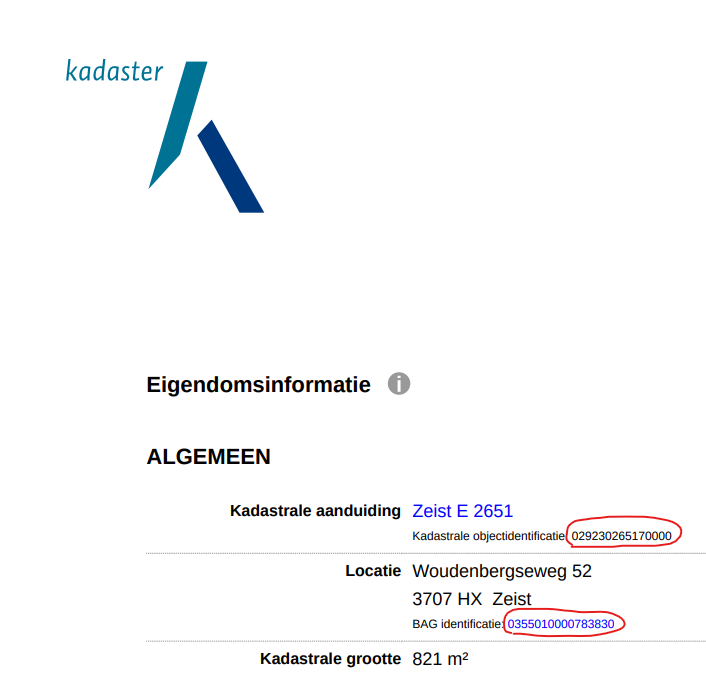
To add to @barthuijbers idea, I do believe there must be another way to link addresses and buildings to parcels. For instance, our dutch colleagues regularly request Eigendomsinformatie (ownership information) from Kadaster which has a clear relationship between the Kadastrale objectidentificatie and BAG identificatie (address id or Verblijfsobject identificatie) as shown in this screenshot
Since this piece of information is already made by Kadaster, it seems they already have this linking information in their databases. Maybe they are already working on it to make it available.
That is very true. The legal rights on a Pand are derived from the legal rights that are registered on the Perceel. Which indeed will be specified in the notarized deed, or follow from the description of Onroerende Zaken and their ownership.
But the register in which that information is stored (Basisregistratie Kadaster, BRK) is not easily and automated accessible, for very good reasons. So if you need the link between Perceel and Pand, your best bet is still the spatial relationship, or a request for that information from Kadaster (which is not an option if you’re talking 4000 Panden or thereabouts throughout NL, which is the amount deal with in my daily work).
And yet: Even taking the legal rights into account, that does not explain some of the anomalies that are being published by the Locatieserver. Specifically this example, which I know very well since those parcels are owned by my employer, does not make any sense to me - and I have access to and have seen the actual deeds on those.
Kadaster is aware of the issue, as far as I know they are indeed working on it, but it is not a trivial task. I’m sure it will be anounced far and wide, including here, if such an administrative link would be available.