Hello,
I’m sorry I don’t speak Dutch so please excuse me.
I’m having a problem when working with this particular dataset from here:
https://www.pdok.nl/geo-services/-/article/beschermde-gebieden-cdda-inspire-geharmoniseerd-
I’m using the WFS server. This is the link which loads an xml:
https://geodata.nationaalgeoregister.nl/inspire/ps-cdda/wfs?request=GetFeature&service=WFS&typeName=ps-cdda:ProtectedSite
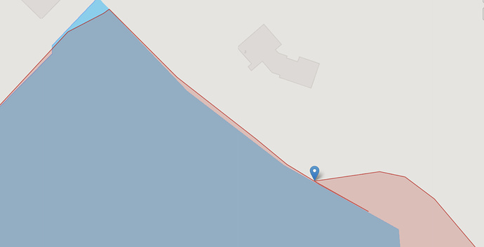
So when I downloaded the data and tried to work with it I noticed that there are a lot of duplicate points which make no sense. To my understanding there can be at most two duplicate points in a single polygon (the first and the last, which closes the polygon). But there are more than two in some of the polygons (in the multipolgyons which are just arrays of polygons). Here is an example of one of the problematic polygons:
The marker shows the staring point of the polygon. So the polygon closes and then continues to make a line and goes back to the starting point (after the polygon closes there shouldn’t be any more points). There are a lot more examples like this in this dataset and even duplicate points which are different from the starting point (which also doesn’t make sense).
I’ve looked at this dataset for a few days and tried to cleanup the data but couldn’t because in some cases there are more than 500 points after the polygon closes (which leads to data loss).
Has anyone encountered such problems with datasets? Is anyone familiar with this particular dataset and do you think that it be fixed in some way?
Also are the maintainers of the dataset here and do you know about this?
Thanks in advance.
