Hi There,
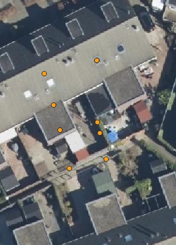
I have a question regarding the projection system used in the Netherlands. I recently came across a GML dataset that appears to be using the Amersfoort / RD New projection system. However, upon further investigation, it seems that this is not the case. Please refer to the attached image for reference:
As you may see, the coordinates displayed in the dataset are situated in the middle of the buildings, which is not expected. This discrepancy has led me to wonder how many projection systems are available for use in the Netherlands.
To provide a concrete example, here is a sample coordinate: 168512.00 442665.00 22.84. These coordinates seem to correspond to a sewage manhole of Achterberg city in the southern region.
I would greatly appreciate any assistance or suggestions you can offer regarding this matter.
There are quite a lot of things that can go wrong with an issue like this, so in order to help you out we’ll need a bit more context:
Where does that point dataset come from, where did you find it? It could be that it was originally in another CRS, and was transformed wrong.
How are you displaying it? In QGis for example you can specify a CRS for every dataset, but also for the entire project (which then causes all datasets to be transformed to the CRS defined for the project).
I agree that the sample coordinate you give seems to be RD. But a bit more context is needed before we can say anything about a possible solution.
Hi Antonbakker,
Thank you for your reaction.
Dataset is not in PDOK. I am using https://data.gwsw.nl/ .
I tested these projection systems:
Projection RD new= “28992”
# Define the RD (Amersfoort) and WGS84 coordinate systems

rd_projection = pyproj.CRS.from_epsg(28991)#7415 and 28992 # old 28991

wgs84_projection = pyproj.CRS.from_epsg(4326)

# Create the transformer

transformer = pyproj.Transformer.from_crs(rd_projection, wgs84_projection, always_xy=True)

# Perform the coordinate transformation

lon, lat = transformer.transform(x, y)

return lon, lat
The most popular projected CRS in the Netherlands is “Stelsel van de Rijksdriehoeksmeting (RD)” registered in EPSG as “Amersfoort / RD New” (EPSG:28992) and often used with height above NAP and named RDNAP (EPSG:7415). However, other projected CRSs, like ETRS89-UTM and Pseudo-Mercator, are used too.
The example coordinates you show look like RD coordinates. So, I expect your problem is not the CRS labeling of your coordinates, but someting else, e.g.:
Your coordinates are wrong beacause they were transformed (by someone else) between RD and another CRS using a wrong coordinate transformation method.
Your coordinates are correct, but are displayed incorrect due to a wrong coordinate transformation method in your viewing software.
Your coordinates are displayed correctly, but your aerial imagery is georeferenced or transformed incorrectly.
The official coordinate transformation method is called RDNAPTRANS™2018. The documentation (English) pdf file can be downloaded after filling in this (Dutch) request form. Incorrect coordinate transformation is quite common for RD. Therefore, we published a coordinate transformation validation service. Other helpful websites are: PDOK viewer, where you can paste RD coordinates in the search bar, and NSGI transformation API or Geopinie transformation tool, to apply RDNAPTRANS™2018.
To help you further, we need more information on what data and software you are using. For instance: are the example coordinates (rounded to metres) supposed to correspond to a sewage manhole in the village Achterberg in the centre of the Netherlands, or is this the wrong location and you would expect them to be somewhere else?
PS: I see more reactions were posted while I was writing this message. What pyproj version do you use?
Do you have a link to the GML dataset? I cannot find a link to a GML download on https://data.gwsw.nl/.
Also can you give a list of feature identifier of the features that end up (presumably) located in the wrong place? Then I can check to reproduce the issue.
I think that is what you are showing in your screenshot, correct? That is a sample dataset which is not a representation of anything real. It’s more to show how Gegevenswoordenboek Stedelijk Water (GWSW) should be used IRL.
Pyproj 3.5.0 seems to use recent PROJ 9 versions, so that should be correct. But you could double check your transformation with the Geopinie tool. If so, I suspect that it is fictional data from Juinen.
No, it’s not a problem with the coordinates. That dataset is a sample dataset, it does not represent anything else than some imaginary data that shows how the GWSW standard should be used in a practical situation. The data itself is made up, nonexistent, even if it is in RD coordinates and inside the Dutch boundaries.
I wanted to mention that I initially thought these data were collected using a total station or GPS. An error occurred during the data collection process.
Your explanation now makes sense to me. Consequently, it appears that these data cannot be used for real-world scenarios.
Side note: The official name is “Stelsel van de Rijksdriehoeksmeting” abbreviated as just “RD”. The name “Amersfoort / RD New” is only used by EPSG and has no official status. The parameters in the EPSG Geodetic Parameter Dataset under code EPSG:28992 are correct, although.
Important note: The link Anton Bakker provides is wrong. It revers to an outdated unofficial copy of the EPSG Geodetic Parameter Dataset. The correct link is https://epsg.org/crs_28992/…